Cannon Mountain-NW Route
- Destination: Cannon Mountain (8638')
- Date: July 13, 2003
- Difficulty: 4+
- Payoff: 3+
- Starting Point: Colchuck Lake Trailhead (c.3400')
- High Point: Cannon Mountain Summit
(8638')
- Round Trip Distance: c.9miles
- Equipment: The ten essentials
- Mountain Skills: Route finding, class 3 rock
Map Courtesy of www.topo.com
Ascent Route
Descent Variation
Possibly Easier Variation
|
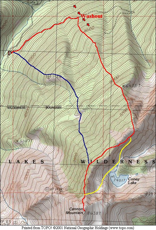 |
This is quite possibly the ugliest route in the Enchantments. I don't
recommend it unless you are looking for the shortest way to the summit of Cannon
Mountain and willing to pay a price to reach it. Let's just say that if I was
going to write a guide with descriptions of 100 summit routes, this
wouldn't be one of them. The route has little to offer in the way of aesthetics
but occasionally has some scenic views.
I met Chris early in the morning, around 4:00am to be more precise. After the
nearly three hour drive from the Federal Way area, we arrived at the Colchuck
Lake Trailhead near Leavenworth. We started up the boulder blocked roadway
heading northeast from the trailhead. One of the guide books, the one without
the index, described the road as reaching a switchback then a washout at 2
miles. We hit a serious wash out well before that and decided to head up from
here (c.4000') rather than deal with the 20 foot dirt cliffs on both sides of
the washout. We ascended several hundred feet from the road on the right side of the
washout, eventually reaching the crest of a rib. It isn't altogether clear whether this
is the rib described in the guide. The rib described is more likely the one just
before (and after) the road switches back
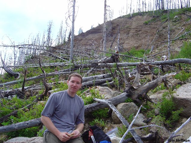
|
Chris in the Forest Near the Top of the Washout
|
|
|
Once on the rib, travel was a bit easier with fewer burned trees to avoid. We
continued southeast up this rib which became indistinct about 400 feet before we
reached the more distinct north ridge of Cannon, just south of point 6475. From
here we continued SSE keeping just right of the crest (cliffs on left) to reach
the top of a couloir (referred to as the North Couloir in the guide). We
debated what to do next. The guide suggesting traversing the ridge, this
appeared to be quite difficult. It looked fairly straight forward to reach Coney
Lake (7401'), then ascend snow and talus to the final notch in the North Ridge
(+8080'), but we were reluctant to descend the 500 feet.
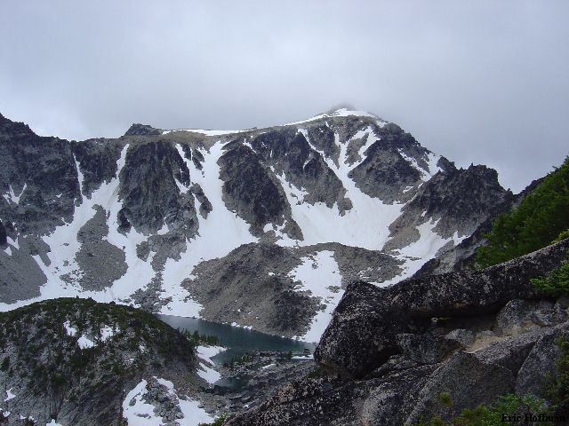
|
Coney Lake and Cannon Mountain (c.7900' on the N. Ridge)
|
|
|
We started out on the east side of the ridge then quickly crossed a notch to
the west side. Travel was easy for a while then we reached several loose gullies
that we crossed to finally gain the final notch in the North Ridge. There
was plenty of up and down to get through the gullies. We probably saved nothing
by avoiding the descent to the lake.
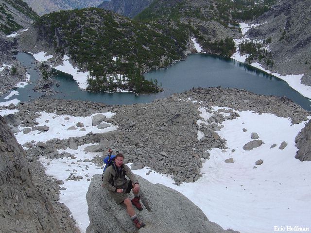
|
Coney Lake from the Last Notch in the North Ridge
|
|
|
From the notch we traversed to a broad gully then ascended toward the summit.
There is much loose debris waiting to be dislodged in this gully. The highest
point of the summit is a large boulder which was surmounted on the SE side
(class 3 slab). The views were okay but the views to many points of interest
were blocked by less interesting terrain features.
|
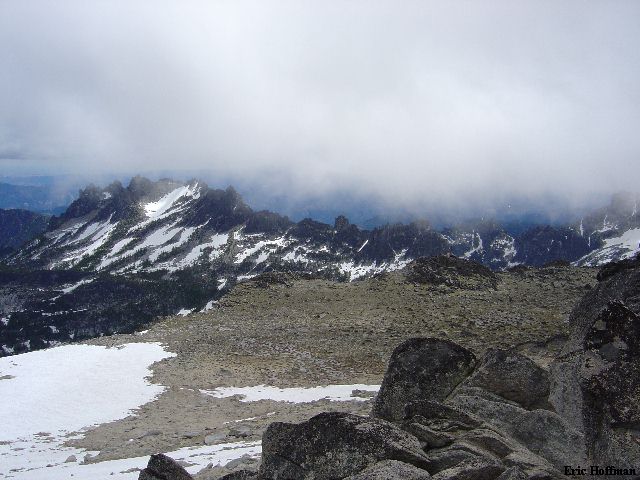
Druid Plateau and Mount Temple Ridge from Cannon
Mountain's Summit
|
|
|
We descended back to the notch then acrossed the gullies to the easier slopes.
We had no interest in returning the way we had came. We began descending and
traversing north until forced to descend between rock bands then continued
traversing to reach a talus slope above a small avalanche basin at c.6000'. We
crossed the talus then traversed to reach a prominent spur that is the boundary
between the forest that had burned and that which had not. We headed down the
spur which turned into a slope near 4500 feet. The steep forested slope quickly
led back to the trailhead. The trip took about 8.5 hours car to car.
|
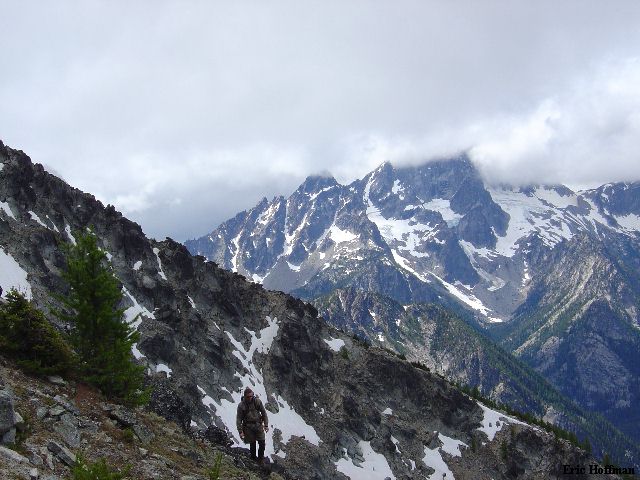
On the Descent: Sherpa Peak and Mount
Stuart
|
|
|
References:
Cascaded Alpine Guide, Volume 1, 2nd Edition; Fred Beckey; Pages 222, 223
Climbing Washington's Mountains; Jeff Smoot; Pages 205-208
USGS 7.5 minute Series, Cashmere Mountain Quadrangle; 1989