The Entiat Mountains are a sub-range of the Cascades that lie east of the Chiwawa River and west of the Entait river. They extend well over 30 mile NW from the south end of Lake Entiat to the town of Holden. The highest summits in the Entait Mountains are in the NW region of the sub-range and include 3 mountains with summits over 9000'. The highest of these is Mt. Fernow at 9249', followed by Seven Fingered Jack at 9100', and Mt. Maude at +9040' (according to my GPS Mt. Maude is actually higher than Seven Fingered Jack). The reason I went to Leroy Creek Basin is because all 3 of these mountains can be climbed from this location.
To get to the Phelps Creek Trailhead take Highway 207 north from Highway 2 (roughly 20 miles East of Stevens Pass) then turn right on Chiwawa Loop Road. Follow Chiwawa Loop Road for a little more than a mile then turn left on Chiwawa River Road. Follow Chiwawa River Road (becomes FSR 62) nearly to its end then (~23miles) turn right on FSR 6211. Follow FSR 6211 to its end and the Phelps Creek Trail Head.
Hike the old roadway that is now Spider Meadows Trail (FST 1511) for about 3.5 miles where it crosses Leroy Creek (~4100'). Immediately after crossing Leroy Creek, a non-maintained trail that reportedly leads to Cairn Mountain heads east. Follow this trail to the lower basin where Leroy Creek is crossed again, then continue for about another half mile to the larger and more spectacular middle basin (good camps sites).
From the middle basin, Mt. Maude to the east and Seven Fingered Jack to the north are almost overwhelming. A small upper basin lies west of Seven Fingered Jack and another to its east below the Jack-Maude Col. If you only plan to explore the Leroy Creek Basin area, the basin and surrounding slopes to the east offer the best views and area to explore. Either basin can be reached by climbing directly up heather and rock, but an easier alternative for reaching the eastern basin may be to continue up the trail (easy to loose in the middle basin) then traverse and/or ascend NE.
From my campsite at 6800' in the upper basin east of Seven Fingered Jack, this was a quick climb. There are a number of westside couloirs that merge near the summit, but the particular couloir that I climbed started the lowest and is easily identified by its the reddish colored rock at its entrance. From the basin traverse southwest and ascend on loose rock to the bottom of the couloir (~7100') then let the fun begin. The climbing is sometimes on clean solid rock and at other times on loose scree and/or boulders. There are serious party inflicted rock fall problems so a solo ascent was nice (definitely a small party size recommended here). The couloir becomes wide and merges with several others near 8700', but then becomes narrow and defined until nearly at the summit. From the top of the couloir, the summit lies a few hundred feet to the east.
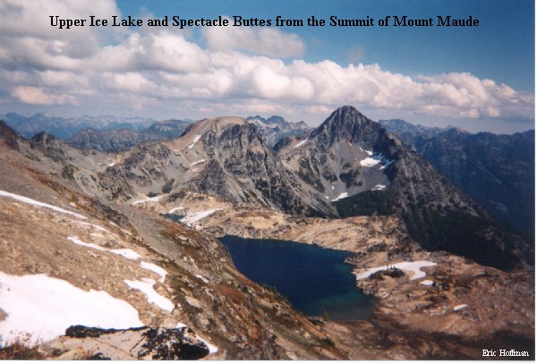
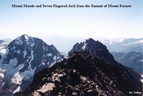
From the summit of Maude one can see the other two nine thousand foot peaks of the Entiat Mountains, the Entiat Glaciers, Ice Lakes and more peaks than you can imagine. From this vantage point, it didn't look like there could possibly be a route across the SE face of Mt. Fernow, but that was a problem for the next day.
I decided to descend the via the South Shoulder Route which is very easy to about 8000'. At this elevation, a descent is made to the west on a giant funnel of rocks that becomes narrower and narrower until it reachs the trees at about 6500'. This was an easier descent than the couloir, but it wasn't much fun and would have been no fun at all to ascend.
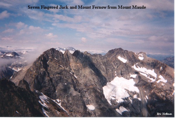
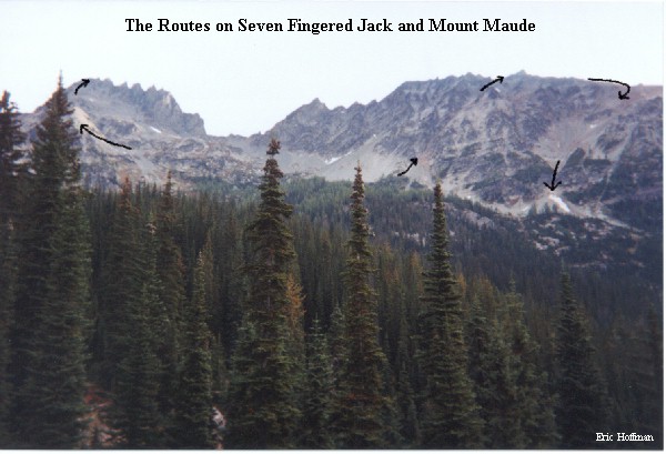
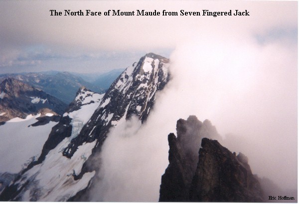
Seven Fingered Jack's true summit is near its north end. My luck with weather didn't let me down on this ascent. Shortly after I started up the bulky ridge leading to Jack's summit, clouds began moving in. By the time I got to 8500', visibility was down to a couple hundred feet or less. When I reached the summit area I climbed what looked like the highest thing around. It wasn't the summit. Repeating this process, I climbed the crag to the north and found that it was not the summit either. Finally after climbing the third crag, I was on the summit. The ascent of the summit crag is class 2-3 and the two crags to the south that I climbed where somewhat more difficult (class 3). The clouds where blowing up and out of Leroy Creek Basin, so I did get a good view to the north and east that included the impressive north face of Mt. Maude. The descent was interesting to say the least with the clouds reaching down to nearly 7000'. Fortunately Seven Fingered Jack has a rather forgiving south slope that can be ascended or descended by a number of possible routes.
The climb of Mt. Fernow from Leroy Creek Basin is a route of necessity rather than of elegance. It is the "simpler" alternative to taking a ferry up Lake Chelan, then travelling by shuttle bus to Holden, then hiking the Railroad Creek Trail to Copper Basin thus allowing access to the standard route (East Ridge Route). It is an interesting route with a couple of major route decisions to make along the way.
From Leroy Creek Basin, hike to the west upper basin and ascend to a low point just west of the obvious 7700' col (2 bivy sites at the low point). From the low point descend a class 3 ridge then decend north on a small unnamed glacier. The glacier has icy slopes of about 40 degrees near the top, then becomes more moderate. There are crevasses but the route stays below them.
Decision 1
Option 1: The standard route descends the glacier to its terminal moraine at about 6500' then ascends on the right side of a steam to an upper snow filled basin. From here ascend SW up a broad gulley that turns toward the east. If you choose this route expect class 2-3 rock climbing and the luxury of knowing where the hell you are.
Option 2: An alternative is to descend the glacier to 7000' (sounds good), then make a rising traverse through numerous gullies, over numerous ribs, and around numerous small cliffs. Eventually this route will merge with the standard route somewhere in the broad gulley. If you choose this route you should be prepared to make it work one way or another (class 3+ rock climbing, some snow and ice) and to have a feeling of being lost somewhere in the Entiat Mountains.
Hmmm....I chose option 2 and found it to be filled with suprises, but I eventually made it to the broad gulley at an elevation of about 7800'.
Decision 2
Option 1: Ascend the broad gulley to the col then traverse the SE face on narrow ledges with exposure that would scare a bird. If you fall the chances of your body being found are questionable.
Option 2: Ascend the broad gulley to about 8400', then climb a loose gulley to about 9000'. At 9000' easily traverse the SE face on a wide ledge that is not exposed at all.
Hmmm...I went with option 2.
The basic idea is to ascend as far up the ridge separating Fernows SE and SW faces. The loose gulley was the best way I found to do that, but there are certainly other ways...too bad I didn't figure it out on the way up.
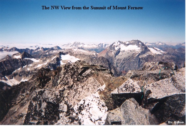
Once on the East Ridge the summit is reached with a couple hundred feet of class 3 climbing on reasonably solid rock with some exposure near the top. The weather was cooperative and I enjoyed a magnificient view along with several people from the Mazama Club in Portland (they climbed via the East Ridge Route). Rainier, Baker, Bonanza, Shuksan, Dome and too many other mountains where available for my viewing pleasure.
On the descent, I followed the standard route and descended to 6500'. I don't think it saved much in the way of time or energy, so decision 1 is a matter of your preference. Anyway you go expect this to be an all day endeavor (took me 9 hours round trip).
This quick trip to the Entiat Mountains did not even come close to an exploration of the sub-range, but it was a great outting that certainly gave me a taste of the area. This is a wonderful area of the North Cascades with better than average weather, yet with the exception of the members of the Mazama Club, I saw no one else on any of these climbs.