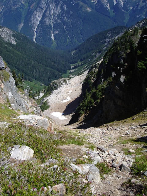
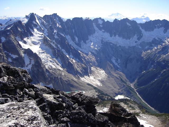
Mount Fury from Big Beaver Creek
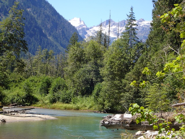
Sergio and I arrived at the Ross Lake Resort Trailhead a little after 10:00am. We had scheduled a boat taxi departing the dock at 11:00AM to take us to the Big Beaver trail. The fee for the taxi service is $30 each way for up to 6 people. Since there were only 2 of us we weren’t really getting our money’s worth but we were willing to pay to avoid adding 12 miles to the round trip distance. At this point our plan was to hike to Luna Camp on the first day, take the Access Creek route to the Luna-Fury Col and climb Luna on the second day, climb Fury and descend at least to the 4400’ basin at the head of the Access Creek drainage the 3rd day, then finish the descent back to Ross Lake to meet our 5:00pm water taxi on the fourth day. Everything was going according to plan when we arrived at Luna camp after the 9.5 mile hike up the Big Beaver Creek trail, unless you happened to be one of the 100, 000 tiny frogs loitering on the trail. Most of them survived.
|
Mount Fury from Big Beaver Creek |
|
|
Departing Luna Camp at about 7:00AM on the second day we hiked about a mile before trying to locate a reasonable way across Big Beaver Creek. Our first attempt was unsuccessful, finding steep banks, plenty of devil’s club and brush but no way across the creek. We returned to the trail and hiked briefly to a spot where there were a few subtle signs that this might be a good spot to leave the trail (a stick sticking out of a stump and a couple of softball sized rocks forced into the end of a sawed log.
We reached Big Beaver Creek just upstream its confluence with Access Creek where we were able to ford the creek in knee deep water. Once across Big Beaver we followed Access Creek keeping on the right side initially. The going was not as bad as I had expected. After crossing a couple of brushy spots we crossed the creek where there is a faint path on the bank (4000-4100 ft).
We arrived at the flat basin at the head of the drainage and gazed up the 1600 feet of steep scree leading to the ridge crest. After a break we headed up a scree gully, traversing left on a bench to another scree gully. Finally, we reached the top where there is a steep traverse on grass beyond which is a spur and extraordinary views of the Southern Pickets. The route to the Luna-Fury Col was obvious from here… in good weather anyhow.
|
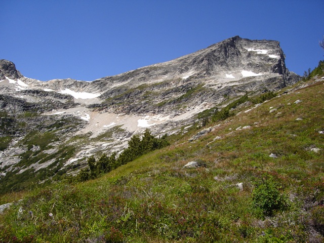
The Access Creek drainage from near the 6100' notch |
|
|
|
Luna Peak from the traverse to the Luna-Fury Col |
|
|
After reaching the col around 3:00PM we found a suitable bivy site. There were several rock walls surrounding small uncomfortable looking bivy sites scattered around the col but only one that was luxurious. After dumping most of our gear, locating water and taking a break we started up the ridge toward Luna. Looking back toward camp the ledge that would lead us to Mount Fury the next day was obvious. It has to be the biggest and most obvious ledge I’ve ever seen.
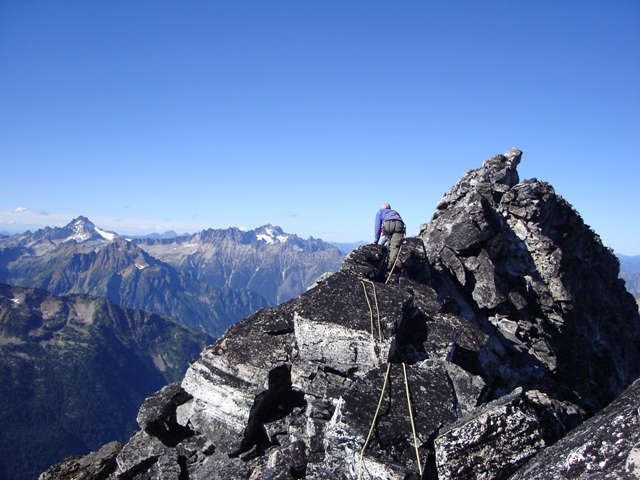
We made quick progress up the easy ridge to the false summit of Luna where we decided to rope up for the class 3/4 section of the ridge. Sergio led the running belay placing only a few pieces. The climbing is easy but very loose and exposed. From the summit area, which is just a narrow sloping slab, the views of the Pickets where as good as they were rumored to be. Wow!
|
Near the false summit with the Southern Pickets in the background |
|
|
|
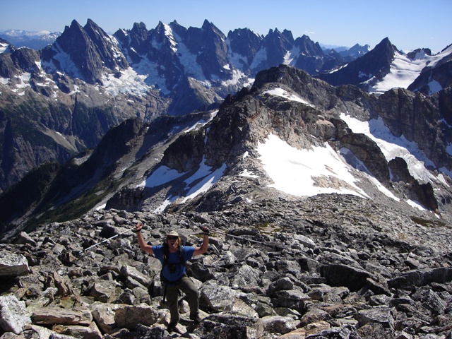
Sergio on the summit ridge with Redoubt, Mox Peaks and Spickard behind |
|
|
|
The Northern Pickets from Luna Peak |
|
|
I lead back to the false summit then we returned to camp. The winds had picked up a little but it looked like we would have more great weather the next day for our attempt of Fury’s SE Glacier.
At around midnight I awoke to the sound of our pot being blown around. I retrieved it and secured it under a large rock. It was still clear but the wind was now blowing hard. I tucked my head into my bivy bag to escape from the sand that was blowing onto my face. Pitter-patter. Pitter-patter. It was 4:00AM and it was raining, so much for another day of good weather.
It rained more on than off for the next few hours. By 9:00AM we have reluctantly given up on the thought of climbing Mount Fury and take advantage a brief pause in the rain to stuff gear into our packs. We reached the steep grass traverse and decide to go above it rather than directly across it. After a 15 minute of looking for the gully in the drizzle we locate it and begin down. It was still raining when we reached the 4400’ basin at the head of Access Creek at noon.
Continuing down the drainage it was easier to follow the faint path on the right side of the creek. Eventually, it became obvious that crossing to the left side was the right thing to do. We continued through the soaked brush, narrowly missing a softball size bee’s nest hanging from a spindly slide alder branch. When we reached Big Beaver Creek, we didn’t even bother taking off our boots before fording to the other side and continued toward the trail in some sort of a Cascade misery induced trance. Only 10.5 miles to go...
References:
Cascade Alpine Guide, Volume 3, 2nd Edition; Fred Beckey; Pages 115, 385
Selected Climbs in the Cascades, Volume 1, 2nd Edition; Jim Nelson and Peter Potterfield; Pages 271-274