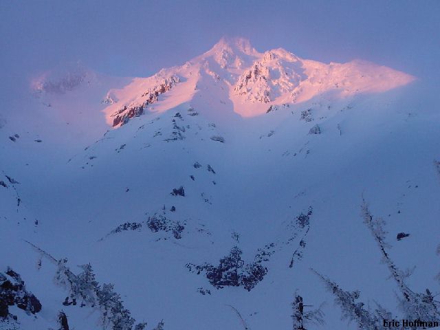
Pamelia Lake and the North Shoulder of Mt. Jefferson
After a lengthy drive to Salem I was heading east on Oregon State Highway 22 looking for Pamelia Lake Road (FST 2246). Finally, just beyond milepost 62 I came to the junction. A sign at the junction said "NW Forest Pass Required", no surprise there, but another sign stating that a permit was required for all, apparently day users included, entering the Mt. Jefferson Wilderness Area via the Pamelia Lake Trail. Hmmm...that's interesting I thought as I continued past the sign. After a few miles, motorized progress was stopped by snow. I decided to take a quick walk up the road to see just how far I was from the trailhead. In about a quarter mile I arrived at the trailhead. The sign on the kiosk was a bit more clear about just who needs a limited entry permit and when. As it turns out, everyone needs a permit from Memorial Day weekend through Oct 31st. Permits are available only at the Detroit Ranger Station and must be gotten in advance. It would probably be wise to call the Detroit Ranger Station (503-854-3366) before making the trip to find out more about the permit system.
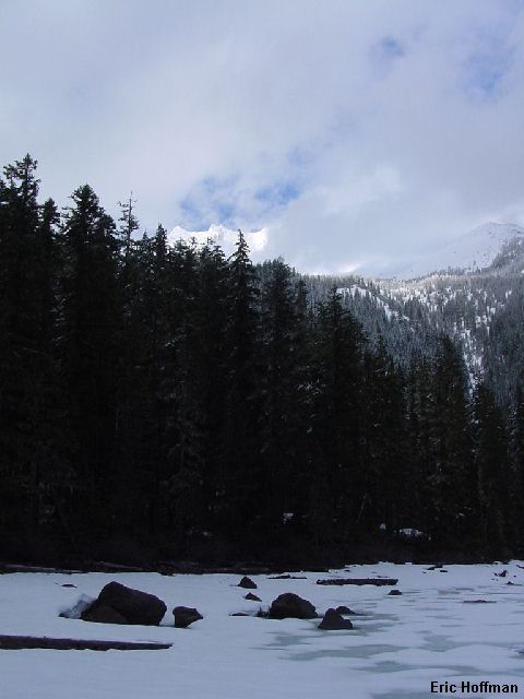
After returning to my car and retrieving my gear, I headed back to the trailhead and began the mellow hike along Pamelia Creek (FST 3439). After 2.2 miles and only 800 vertical feet I arrived at the lake. I stopped there hoping to get my first view of Mount Jefferson. After only a few minutes, the mostly cloudy sky parted and I got a partial view of the mountain.
|
Pamelia Lake and the North Shoulder of Mt. Jefferson |
|
|
After a short search for the junction of FST 3440 at the lake, I gave up and headed north up a broad forested gully that seemed like the likely route. The trail leads to a junction with the PCT in 0.7 miles and from there the best route after the snow is gone is unknown, but there is little doubt that there is a path of some sort to tree line near the SW ridge. The route I took continued directly up the broad gully until I reached the steep drop down to Milk Creek.
|
Mount Jefferson from above Milk Creek |
|
|
Once I was on the crest above Milk Creek it was easy traveling with good views. I reached tree line and my camp for the night near 6000'. The weather wasn't great yet, but there were definitely signs that things were improving. The temperature was cold and I was surrounded by what could only be described as powder, about 6 inches deep in areas protected from the wind. The winds had been from the north and there was definite evidence that some transport had occurred along with some wind slab formation on the south side of the crest. I settled in for the evening with plummeting temperatures, low winds and great views.
|
Mount Jefferson catching the last rays of sunshine |
|
|
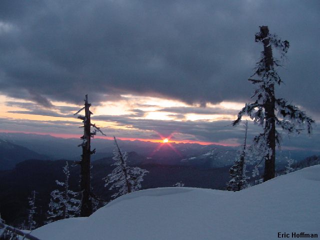
|
Sunset from camp |
|
|
I slept until relatively late, not really seeing any reason for an alpine start to climb on a ridge, and because it was COLD! By 7:30am I had hot coffee and found that my tube of sunscreen had burst. I was left with half frozen, half dried paste...but my compass and map were now protected with liberal quantities of SPF 30. I started from camp on skis working my way toward the ridge crest in fresh powder. By 7000' the snow had turned to a solid wind crust. I reached the ridge crest at 7300' and left my skis there. The snow from there was great for crampons, but not so great for skiing (plenty of good ski opportunities remain in the area). The view from the ridge crest was exactly what I had hoped.
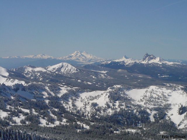
|
More Volcanoes! Broken Top, Three Sisters, Washington and Three Fingered Jack (left to right) |
|
|
I had come to Mt. Jefferson knowing that I would be very lucky to actually reach the summit. The final 400 feet or so of this volcano is the crux of just about any route up. The SW ridge is one of the easiest ways to reach the pinnacle, unfortunately not on the best side though. My only hope for reaching the summit was that I could get across the traverse, described as treacherous, to the north side, then finish the climb on the what would hopefully be loose class 3 and 4 rock buried under deep snow. The ridge itself, even if it isn't described as the most aesthetic, was interesting under the conditions. Everything that the wind had hit was covered with rime, everything including the summit pinnacle which was getting closer by the minute.
Meanwhile, at the only camp on this side of the mountain, a curiously intelligent bird was busy pecking away at the cord that was securing a food bag to a tree limb. It's relentless effort was finally rewarded when the bag dropped to the snow. It sampled the coffee, the strawberry and cream oatmeal and the Lipton cup of soup, but it was the instant mashed potatoes that really satisfied it hunger. After eating the entire package, it cleaned it beak with Aquafresh toothpaste. Not a single package left untouched, it flew away, no doubt in search of water to reconstitute a belly full of instant mashed potatoes.
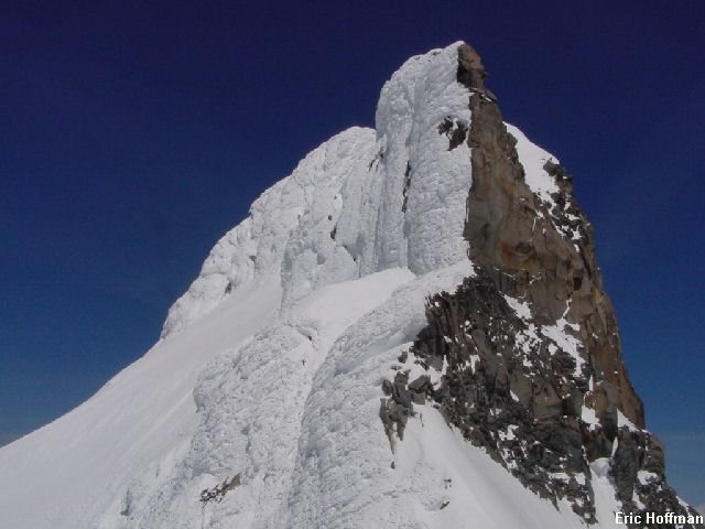
Back on the mountain, I arrived at Red Saddle (c.10,000 feet) and stared at the pinnacle for a while. The east side dropped steeply away to the Whitewater Glacier. The south face has a 5.6 route, supposedly reasonable after the initial loose rock is overcome. Two options remained, both of which involved the traverse: a loose class 4 gully leading to a notch in the summit pinnacle, and the standard system of class 3 and 4 ledges on the north side. I started out across the traverse on a solid wind crust. Eventually I hit a patch of water ice concealed by a thin layer of fresh snow. I wasn't really happy about having a pile of loose rock coated with rime hanging above me as I slowly made my way toward what was likely a wind slab resting on smooth ice. The class 4 gully was above me, covered in rime. It was time to get off the mountain.
|
The Summit Pinnacle from Red Saddle |
|
|
After descending the ridge and retrieving my skis, I enjoyed some pretty good skiing back to camp where I found trash scattered about by a bird that obviously doesn't have a thorough understanding of the leave no trace concept. After about another 1500 feet of skiing toward the lake on increasingly thin snow and thickening brush, I was fortunate enough to locate the PCT near 4400' which quickly lead back to the broad forested gully for an easy descent back to the lake.
references:
Summit Guide to the Cascade Volcanoes; Jeff Smoot; Pages 117-125