Mount Triumph from Terror Basin (August 10, 2002)
At 7,240 Feet, Mount Triumph is far from a giant of the North Cascades. The appeal is its location and, of course, its appearance. There is no easy way to the summit. The easiest route appears to be the west route (class 4) which begins near Triumph Pass, but first you have to get there. The NE Ridge route provides easier access but the climbing is more difficult and presumable more exposed. Late season brought us a sketchy glacier crossing which won't necessarily be easier in early season, but should prove to be safer. The route is exposed, the rock is not great, and the protection if often poor, but there are good ledges for belays and the setting is excellent. Expect time to be an issue.
|
Mount Triumph from Terror Basin (August 10, 2002) |
|
|
I picked up Paul Klenke around 9:00am and then Sergio Verdina. After a stop in Marblemount for a camping permit, we headed for the Thornton Lake Trailhead. Our permit was for one night in the Mount Triumph XC Zone. We departed the trailhead (c.2500') at about 1:00pm. The trail follows an old roadway for about 2 miles, gaining little elevation. At the end of the old road the trail continues, becoming a bit steeper. At just under 5 miles there is a junction. We went left toward Thornton Lake. The unofficial trail to the right leads to Trapper Peak. Just beyond the junction an overlook of Thornton Lakes is reached (c.5000') and the trail descends to the lowest and largest of the 3 lakes. At 5.3 miles the trail officially ends at the outlet of the lake (4486'). There is a camp at the outlet of the lower lake but this would leave one with a very long summit day. We were heading for the more traditional camp site near the +5840' col NW of the middle lake (between 6935' Thornton Peak and Point 6125').
At the outlet of the lower lake we located a path beginning around the left side of the lake. After a hundred feet it led steeply up to the divide above where we quickly reached a more obvious path (this path begins in the maze of trails at the camp). Once on the divide we followed the sometimes brushy path to the creek between the middle and lower lake. We crossed the creek and followed a couple of cairns then a faint path through steep, brushy terrain to the middle lake. Continuing around the right side of the middle lake, we continued up the obvious gully toward the col. There is a path below the cliffs on the right side of the gully which made travel easier.
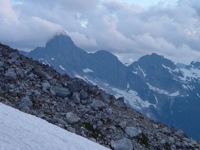
Selected Climbs in the Cascades states that the park service asks people to camp at a bivy sight near the glacier, a couple hundred feet below the col (NW of the col). The park ranger, however, insisted that the bivy sight was SE of the col. Finding no bivy site below, we weighed our options. Should we believe the rangers, what the book says the rangers say and continue down the other side, or should we camp at the col? Hmmm, there were good bivy sights at the col and no one was compelled to descend to the glacier to find out if if there is or isn't a bivy sites below. We set up camp at the col. Water was available near the glacier...where there are small bivy sites on a hump of gravel. Apparently, we were supposed to believe what the guide book says the rangers say, and not what the rangers told us? The views from the col are spectacular. It took a little over 4 hours to reach the camp from the trailhead.
|
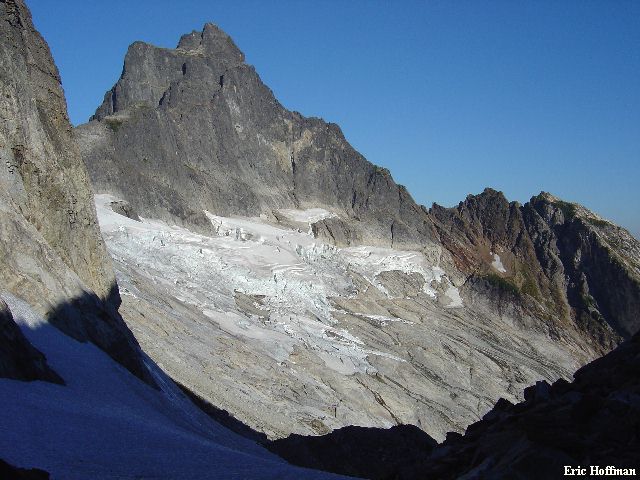
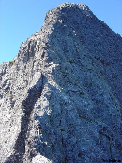
Mount Triumph from the Col (The NE Ridge is the Right Skyline) |
|
|
|
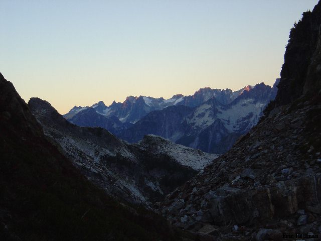
A View of the Pickets from the Col |
|
|
We got underway the following morning at about 6:15 following a somewhat sleepless night featuring gusty SW winds. After descending two hundred feet we passed the gravel hump on the left then climbed down a narrow moat in a gully to reach talus below (expect steep snow in the gully). Once on the talus we began traversing toward slabs and a very thin and broken glacier. Avoiding the glacier as much as possible and moving quickly was the method we used. We were unable to avoid the glacier altogether but found our way to the slabs below where other than slick slabs with running water the travel was easy. The traverse across the slabs was exposed to sliding blocks of snow and ice. We aimed for a gully (the shorter, right slanting one to the right of a longer, steeper, left slanting one). Climbing this proved to be easier than it had appeared. A couple class 4 moves at the base of the gully reached easier travel above. We quickly exited the gully and climbed up and left to a grassy ledge that provided a straightforward route to the the obvious notch (class 3, +6080') in the NE Ridge.
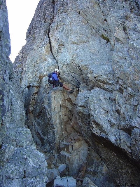
More serious climbing begins at the notch. From just below the notch, we worked left around the first small horn then up to a rappel station (class 3/4, all the slings were cut). We roped up here using twin ropes and hoped to use running belays as much as possible. We started up the ridge which was mostly class 3 and 4 for the first several hundred feet. There are small bivy sites on the ridge at 100-200 feet above the notch. The lower ridge climbing was mostly uneventful, class 3 and 4 with occasional low 5th class.
|
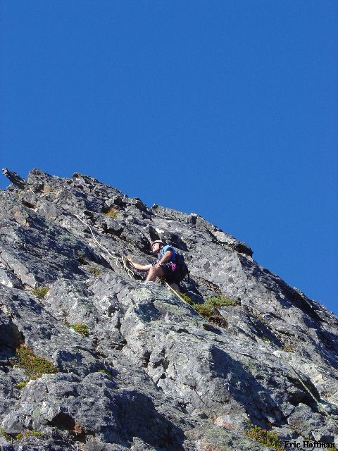
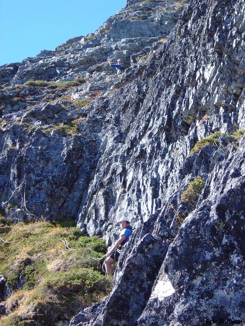
Climbing on the Lower Ridge |
|
|
About halfway up the ridge the climb starting becoming more difficult and exposed. Paul, who led the entire route, climbed up and over two small horns on the otherwise horizontal ridge crest to arrive at a 50 foot knife edge. Just beyond this the climbing became considerably steeper and more difficult.
|
Sergio and Paul Examining the Upper Ridge |
|
|
Low fifth class led to mid fifth as we approached the intimidating right slanting crack (reportedly 5.6 to 5.7). Paul first tried to bypass the crack on the left, then took a closer look at the crack before finally working to the right of it where 5.6 rock allowed a bypass. Above this there was another short step. Paul used a shoulder/face stand to reach the top of the step and put Sergio on belay. Sergio made it look easy...it was all about how far you could reach. Being the shortest, I was unable to reach the top holds... Hmmm. I worked right up broken rock to a small overhang. I made a reach for the top only to find heather and loose rock... After sliding down a foot with a clump of heather in each hand (THANK YOU for the belay Sergio) I worked a couple more feet to the right where I found a way into the easy chimney above (class 2/3).
|
Paul Appoaching the 5.7 Crack, Sergio Gets Across the Knife Edge |
|
|
We ascended the chimney to the top then continued 30 feet on a ledge ending at the right side of a broad gully. Paul climbed the gully then traversed left on another ledge. A few class 3/4 moves reached the upper portion of the broad gully and class 3 climbing to the summit.
|
Paul Indicating It's Easy from Here, Segio Smiles on the Grassy Ledge |
|
|
It was a little before 1:00pm, the ascent had taken about 6.5 hours. The summit views were extraordinary but we spent little time enjoying them. Sergio called his wife, informing her that we may not make it back to the trailhead that night as originally planned. The descent was looking like it would take a long time.
|
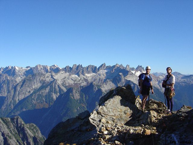
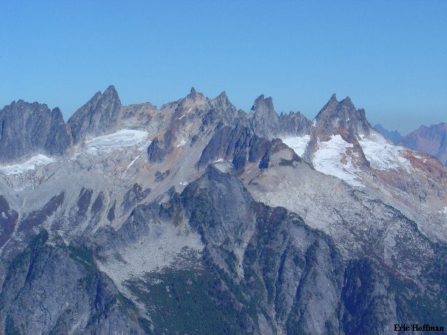
Most of the Southern Pickets from the Summit of Mount Triumph |
|
|
|
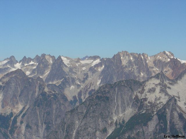
And, the Northern Pickets |
|
|
We downclimbed about a hundred feet to a rappel sling. A double rope rappel reached the edge of the Chimney. A second double rope rappel reached the bottom of the chimney (this is a steep, overhanging rappel, double rope required, the gully is the way to go if you only have one rope).
|
Let the Descent Begin: Sergio Rappels into the Chimney |
|
|
Our third double rope rappel got us past the steepest part of the ridge and back to the knife edge. We downclimbed the knife edge then made another rappel. By the time we reached the notch we had made 7 double and 2 single rope rappels. We downclimbed what we deemed safe in an effort to expedite the descent. Darkness was setting in as we reached the col a little after 7:00pm. For practical purposes, it had taken as long to descend as it had taken to reach the top.
After another night at the col (less wind and less food) we headed down. The rangers had called Sergio's wife who informed them that we may be out later than we had expected. We departed camp around 9:30am, reaching the trailhead at about 1:00pm. We headed to the ranger station to sign out then to get GOOD FOOD!
References:
Cascade Climbers Guide, Volume 3, 2nd Edition; Fred Beckey; Pages 86-90
Selected Climbs in the Cascades, Volume 2; Jim Nelson and Peter Potterfield;
Pages 185-190