Mount Wow from near Lake Allen
They say that desperate times call for desperate measures and I was beginning to feel desperate after being shutout the past 2 weekends. Mount Wow is a modest peak in the southwest corner of Mount Rainier national park. Despite its cliffy East face, more than 2000 feet of prominence, excellent views of the west side of Mount Rainier and a general lack of brush, Mount Wow goes largely unnoticed. Mount Wow turned out to be a good choice in a desperate time.
I drove to the Nisqually entrance of the park and continued to the West Side Road. In 1.9 miles I parked at a small pullout on the right where there is room for about 4 cars… certainly plenty of room for one as will likely be the case. I was ready to hike by 8:15AM.
About 50 feet up the road there was a small game trail descending to the road. I started up this knowing I would find what remained of the fisherman’s trail to Lake Allen. I had scouted this area before in search of the trail and had found it with only minor difficulty. While the trail is not maintained it is not gone and can be followed reasonable well on the way to Lake Allen. It seemed even easier to follow on the way down. Even if you cannot follow the trail to Lake Allen the route is still viable and fairly obvious. A good rule of thumb is that if are doing more than hiking through steep forest you are off route.
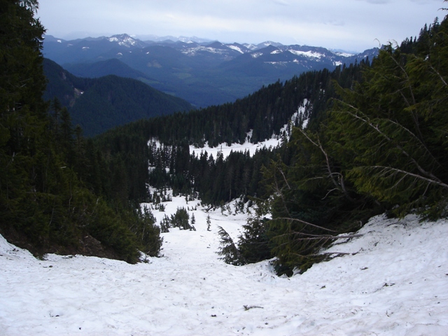
The trail starts off by climbing to a rib on the right about 100 feet above the road. After about 400 feet on the rib it ends at an area of steep moss covered rock. From here the trail traverses right then continues up and right to another rib. This one is followed for perhaps 800 feet before the trail moves left then up a forested slope. At about 4500 feet the trail traverses left above more steep moss covered rock to a flatter area where I lost it in snow. I continued in the direction of Lake Allen (WSW) and arrived there in about 5 minutes. From here I got my first look at the avalanche path on the south side of the mountain.
|
Mount Wow from near Lake Allen |
|
|
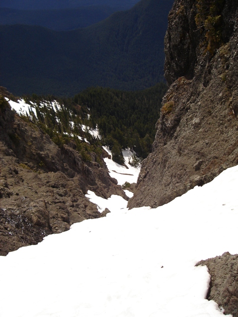
Beckey describes a trail up the ridge on the left but I doubted its existance and even if it did it was concealed by several feet of snow. I headed straight up the relatively low angled avalanche path. Near the summit I could see three gullies and it appeared that summit was probably on the right. As I got closer I decided to take the left gully which had continuous snow and looked easier than the center or right gullies but harder than going to the ridge on the left.
|
Lake Allen from the avalanche Chute |
|
|
The gully got steeper than I had initially thought and I switched to my ice axe. The snow was good for climbing: not too soft and not icy. The gully had a couple of moats and a bit of a constriction with some steeper snow (45 degrees) for the last 100-200 feet. I was happy to discover that the left gully led directly to the summit which is the high point of a long narrow crest trending N-S. It took 2 hour and 15 minutes to reach the summit from the West Side Road.
|
Looking down the left gully |
|
|
On the descent I took the ridge described by Beckey (on the right as you descend) which is straight forward. After descending about 300-400 feet I turned left and traversed back into the avalanche path. From here I retraced my steps and followed the path to arrive at my car a few minutes before noon.
|
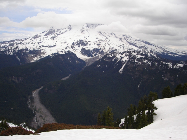
The Obligatory Photo |
|
|
Peggy Goldman's book, "75 Scrambles in Washington," describes a route from the park entrance via the Boundary Trail. This route appears to offer no advantages. She also describes the route via Lake Allen... almost word for word from the Beckey guide... including the incorrect distance to drive on the west side road. Drive 1.9 miles, not 1.5 if you want to find the trail!
References:
Cascade Alpine Guide, Volume 1, 2nd Edition; Fred Beckey; Page 124
USGS 7.5 Minute Quadrangle; Mount Wow, WA; 2000